
The Grand Canyon is a steep-sided canyon carved by the Colorado River in Arizona, United States. The Grand Canyon is 277 miles (446 km) long, up to 18 miles (29 km) wide and attains a depth of over a mile.

Parker is the county seat of La Paz County, Arizona, United States, on the Colorado River in Parker Valley. As of the 2020 census, the population of the city was 3,417.

Gunnison is a home rule municipality that is the county seat and the most populous municipality of Gunnison County, Colorado. The city population was 6,560 at the 2020 United States Census. Gunnison was named in honor of John W. Gunnison, a United States Army officer who surveyed for a transcontinental railroad in 1853.

Yardley is a borough in Bucks County, Pennsylvania. Yardley borders the Delaware River and Ewing, New Jersey to its east and Lower Makefield Township to its north, west, and south. The United States Post Office assigns many addresses in Lower Makefield Township the preferred city of "Yardley", although they are outside the borough. The population was 2,434 at the 2010 census. Yardley is part of the Delaware Valley metropolitan area.

Moab is the largest city and county seat of Grand County in eastern Utah in the western United States, known for its dramatic scenery. The population was 5,366 at the 2020 census. Moab attracts many tourists annually, mostly visitors to the nearby Arches and Canyonlands National Parks. The town is a popular base for mountain bikers who ride the extensive network of trails including the Slickrock Trail, and for off-roaders who come for the annual Moab Jeep Safari.
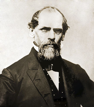
John Augustus Roebling was a German-born American civil engineer. He designed and built wire rope suspension bridges, in particular the Brooklyn Bridge, which has been designated as a National Historic Landmark and a National Historic Civil Engineering Landmark.

The Washington Monument is an obelisk-shaped building, on the National Mall in Washington, D.C., built to commemorate George Washington, a Founding Father of the United States, victorious commander-in-chief of the Continental Army from 1775 to 1784 in the American Revolutionary War, and the first President of the United States from 1789 to 1797. Standing east of the Reflecting Pool and the Lincoln Memorial, the monument, made of marble, granite, and bluestone gneiss, is both the world's tallest predominantly stone structure and the world's tallest obelisk, standing 554 feet 7+11⁄32 inches (169.046 m) tall, according to the U.S. Geodetic Survey measurements in 2013–2014. It is the tallest monumental column in the world if all are measured above their pedestrian entrances. It was the tallest structure in the world between 1884 and 1889, after which it was overtaken by the Eiffel Tower, in Paris. Previously, the tallest structure was the Cologne Cathedral.

Dinosaur National Monument is an American national monument located on the southeast flank of the Uinta Mountains on the border between Colorado and Utah at the confluence of the Green and Yampa rivers. Although most of the monument area is in Moffat County, Colorado, the Dinosaur Quarry is located in Utah, north of the town of Jensen, Utah. The nearest Colorado town is Dinosaur while the nearest city is Vernal, Utah.
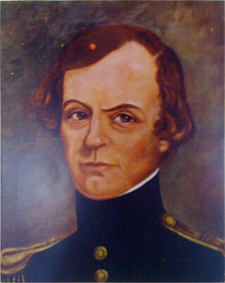
John Williams Gunnison was an American military officer and explorer.

The known human history of the Grand Canyon area stretches back 10,500 years, when the first evidence of human presence in the area is found. Native Americans have inhabited the Grand Canyon and the area now covered by Grand Canyon National Park for at least the last 4,000 of those years. Ancestral Pueblo peoples, first as the Basketmaker culture and later as the more familiar Pueblo people, developed from the Desert Culture as they became less nomadic and more dependent on agriculture. A similar culture, the Cochimi also lived in the canyon area. Drought in the late 13th century likely caused both groups to move on. Other people followed, including the Paiute, Cerbat, and the Navajo, only to be later forced onto reservations by the United States Government.

Ratón Pass is a 7,834 ft (2,388 m) elevation mountain pass on the Colorado–New Mexico border in the western United States. It is located on the eastern side of the Sangre de Cristo Mountains between Trinidad, Colorado and Raton, New Mexico, approximately 180 miles (290 km) northeast of Santa Fe. Ratón is Spanish for "mouse". The pass crosses the line of volcanic mesas that extends east from the Sangre de Cristo Mountains along the state line, and furnishes the most direct land route between the valley of the Arkansas River to the north and the upper valley of the Canadian River, leading toward Santa Fe, to the south. The pass now carries Interstate 25 and railroad tracks.

The Cumbres and Toltec Scenic Railroad, often abbreviated as the C&TSRR, is a 3 ft narrow-gauge heritage railroad that operates on 64 miles (103 km) of track between Antonito, Colorado, and Chama, New Mexico, in the United States. The railroad is named for two geographical features along the route: the 10,015-foot (3,053 m)-high Cumbres Pass and the Toltec Gorge. Originally part of the Denver and Rio Grande Western Railroad's narrow-gauge network, the line has been jointly owned by the states of Colorado and New Mexico since 1970. Today, the C&TSRR is one of only two remaining parts of the former D&RGW narrow-gauge network, the other being the Durango and Silverton Narrow Gauge Railroad (D&SNG), which runs between the communities of Durango and Silverton, Colorado. The railroad has a total of ten narrow-gauge steam locomotives and two narrow-gauge diesel locomotives on its current roster. The railroad also operates two smaller former D&RGW steam locomotives, Nos. 315 and 168, for special events and excursions.

The Carrollton Viaduct, located over the Gwynns Falls stream near Carroll Park in southwest Baltimore, Maryland, is the first stone masonry bridge for railroad use in the United States, built for the Baltimore and Ohio Railroad, founded 1827, and one of the world's oldest railroad bridges still in use for rail traffic. Construction began in 1828 and was completed in 1829. The bridge is named in honor of Charles Carroll of Carrollton (1737–1832), of Maryland, known for being the last surviving signer of the Declaration of Independence, the only Roman Catholic in the Second Continental Congress (1775–1781), and wealthiest man in the Thirteen Colonies of the time of the American Revolutionary War (1775–

The Black Squirrel Creek Bridge carries U.S. 24 over Black Squirrel Creek in El Paso County, Colorado. Prior to 2012, it was locally known as the "green bridge" or "old green bridge"—a historic single-span, Parker through truss bridge that was completed in 1935 and listed on the National Register of Historic Places in 2002. Because it no longer met highway safety standards, the bridge was dismantled and replaced by a newer span in 2012.
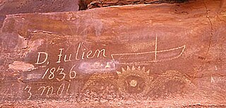
The Denis Julien Inscription is an incised carving on a rock face in a side canyon of the Green River north of Canyonlands National Park in southwestern Grand County, Utah, United States. The site is about 750 feet (230 m) to the east of the Green River in Hell Roaring Canyon, at the top of a talus slope. The inscription was left by trapper Denis Julien in 1836, when he was one of the few Europeans in southern Utah. The panel reads:
D. Julien
1836
3 mai
Denis Julien was an American fur trapper of French-Canadian Huguenot origin best known for his activity in the southwestern United States in the 1830s and 1840s, at a time when he was one of the few people of European descent in the area. He is principally remembered for his habit of leaving carved inscriptions on rock faces in Utah and Colorado during his travels. At least eight such markings have been positively attributed to him, four of which are listed on the National Register of Historic Places.
The Denis Julien Inscription was left on a rock face in 1838 along the Green River in Moffat County, Colorado by Denis Julien, a French-American trapper who was one of the few Europeans in the area in the 1830s. Julien made a practice of leaving his mark on locations along the Green and Colorado rivers, leaving at least eight such marks. Four, including the Colorado mark, are listed on the National Register of Historic Places.
Mantle's Cave is a cliff alcove in Dinosaur National Monument in Moffat County, Colorado. Located in the Castle Park region of the park, it is the largest rock shelter in the area. It was discovered before 1921 by local ranchers, Mr. and Mrs. Charles Mantle. Mrs. Mantle is reported to have done some excavation of the site, followed up by the Penrose-Taylor expedition of 1933 from Colorado College and the Fountain Valley School, which designated the site "Cave One." The site is a significant resource for the Fremont culture and is among the best resources in northwestern Colorado. Excavations in the 1930s and 1940s yielded significant material on the Fremont people and their relationship to the later Ancestral Puebloans.

Rio Grande Southern Railroad (RGS), Motor No. 2 is a gasoline engine-powered narrow gauge railroad motorcar. It was converted on August 12, 1931 from a 1927 Buick Master Six 4-door sedan in a conversion known as a Galloping Goose. The Buick was cut behind the rear doorpost and extended with sheet metal 18 inches (46 cm) to form an enlarged passenger compartment. With no functional use, the steering column was removed. The couch from the RGS office become the back seat as it is shown being requisitioned for Goose No. 2 on the statement covering construction. The front axle was removed and replaced with a swiveling, two-axle lightweight railroad truck with 16 in (41 cm)-diameter wheels that carried and guided the front of the Goose. Ahead of the front truck the pilot is attached to the frame. There were two small pivoted scrapers attached to the rear of the pilot to keep small objects on the track from derailing the lightweight front truck. During the winter season a small snowplow was attached to the front of the pilot.

The Jim Baker Cabin was built in 1873 by frontiersman Jim Baker as a fortified house on the Little Snake River at Savery Creek near present-day Savery, Wyoming. The two-story log building measures 31 feet (9.4 m) by 16 feet (4.9 m) with two rooms on the lower level and a single smaller room on the upper level. The outer walls are made of logs 12 inches (30 cm) to 15 inches (38 cm) thick.

